Travelling Stock Routes and Reserves (TSR's)
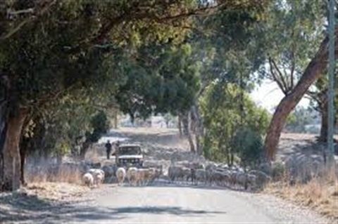
Travelling Stock Routes, forming ‘The Long Paddock’ of routes that traversed inland Australia, were established as an authorised thoroughfare for the walking of domestic livestock such as sheep or cattle from one location to another.
Pioneered by colonial explorers and overlanders, many of the TSR’s were located along corridors that followed river systems, indigenous trade routes and trails. Easily distinguished from an ordinary country road, the grassy verges on either side of the road are very much wider so the livestock may feed on the vegetation as they travel. The travelling stock had to travel ‘six miles a day’ (approximately 10km), to avoid all the grass from being cleared in a particular area. A Reserve is a fenced paddock set aside at strategic distances to allow overnight watering (from bores, dams, windmills and troughs) and camping of stock.
Before the railways were extended cattle were often walked up to 3,220 kilometres (2,000 miles) on the main stock routes. From the early 1900s the state governments established a program to develop stock route water facilities, each located the distance of a droving day apart.
TSR’s are also used as emergency refuges during floods and drought, local agistment, public recreation or as corridors for native vegetation ecosystems, providing a crucial habitat for flora and fauna, connectivity for many endangered species and ecosystems, thus providing a comprehensive sample of the landscape and biodiversity of eastern Australia prior to the colonial period. Some of the shire’s more notable TSR’s such as Brittas, Henty, Back Creek, Kirndeen, King’s and Ten Chain are also part of our bird watching trails.
Information on NSW travelling stockroutes can be found here.